
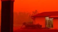
The unusual and striking phenomenon of deeply orange to reddish skies blanketing several regions across Kalimantan has recently captured widespread public attention, spreading rapidly across various social media platforms. Residents in affected areas awoke to an apocalyptic-like atmosphere where the sun was obscured by a dense, murky veil, casting an unnatural amber glow over residential neighborhoods, roadways, and tropical rainforests alike. While the visual spectacle drew immediate comparisons to scenes from science fiction films or distant planetary landscapes, atmospheric scientists and researchers quickly moved to reassure the public, explaining that the mesmerizing yet alarming coloration is the direct result of particulate matter from land and forest fires interacting with solar radiation in the earth’s atmosphere.
According to Professor Thomas Djamaluddin, a prominent Research Professor in Astronomy and Astrophysics at the National Research Agency (BRIN), the atmospheric anomaly is fundamentally driven by heavy smoke saturation in the troposphere. Djamaluddin elucidated that the deep orange and reddish hues emerge due to a well-documented optical physics process known as Rayleigh scattering and Mie scattering. As dense plumes of smoke—comprising microscopic carbon particles, ash, and organic compounds—accumulate in the lower layers of the atmosphere, they selectively scatter shorter wavelengths of light, such as blue and violet. Meanwhile, the longer wavelengths, specifically red, orange, and yellow, are able to penetrate the particulate barrier more effectively, ultimately reaching the human eye and painting the horizon in dramatic, fiery shades.
Chronology and Geographical Spread of the Haze Event
The progression of the haze-induced orange skies did not occur overnight, following a distinct chronological build-up tied to regional meteorological conditions and escalating hotspots. The sequence of events typically begins during the peak of the dry season, exacerbated by cyclical climatic patterns such as the El Niño-Southern Oscillation (ENSO), which significantly suppresses rainfall across the Indonesian archipelago.
In the weeks leading up to the viral social media posts, satellite monitoring systems operated by the Meteorology, Climatology, and Geophysical Agency (BMKG) and the Ministry of Environment and Forestry (KLHK) detected a steady escalation in thermal hotspots across the provinces of Central Kalimantan, West Kalimantan, and South Kalimantan. These hotspots—indicative of active fires—multiplied rapidly as land-clearing practices and accidental blazes spread unchecked through peatland and forested terrain.
As prevailing wind patterns shifted, massive columns of smoke generated by these fires were funneled across populated urban centers and rural districts alike. By the early morning hours, when the sun sits low on the horizon, the cumulative optical thickness of the smoke layer reached a critical threshold. Residents in cities such as Palangka Raya, Banjarmasin, and Pontianak reported the sudden onset of the orange sky phenomenon just after sunrise. The eerie glow persisted throughout the day in severe cases, particularly when thick smoke combined with morning fog to create a persistent, ground-level smog that severely degraded horizontal visibility.
Scientific Breakdown: The Physics of Smoke-Induced Atmospheric Optics
To fully comprehend why the skies turned the color of embers, one must examine the interaction between light and aerosol particles suspended in the air. Under normal, clear-sky conditions, Rayleigh scattering causes the sky to appear blue because molecules in the air scatter short-wavelength blue light in all directions more efficiently than other colors.
However, when a massive influx of smoke enters the atmosphere, the particulate composition changes dramatically. Smoke particles are significantly larger than air molecules—ranging from sub-microns to several micrometers in diameter—meaning they cause Mie scattering rather than Rayleigh scattering. Mie scattering is less dependent on wavelength than Rayleigh scattering, but when smoke concentrations reach extreme densities, a selective filtering effect takes place.
The dense blanket of particulate matter acts as a physical filter that absorbs and scatters away the blue, green, and violet components of sunlight entirely. Only the longest wavelengths—the red and orange spectrum—manage to navigate the labyrinth of suspended carbon soot and ash particles. When the sun is near the horizon during sunrise or sunset, sunlight already has to travel through a thicker slice of the atmosphere, compounding the scattering effect. When combined with a dense smoke layer overhead, this natural twilight phenomenon is intensified to an extreme, unnatural degree, transforming daylight into a perpetual, suffocating dusk.
Supporting Data and Environmental Context
The appearance of orange skies serves as a stark visual indicator of a much larger, systemic environmental challenge that recurs with varying severity across Indonesia. Historical data compiled by disaster management agencies underscores the cyclical nature of forest and land fires (Karhutla) in Kalimantan and Sumatra, particularly during prolonged dry spells.
Peatland ecosystems, which cover vast expanses of Kalimantan, are exceptionally vulnerable. Unlike mineral soil fires, underground peat fires can smolder undetected for weeks or even months, consuming carbon-rich organic soil layers and releasing staggering volumes of greenhouse gases and fine particulate matter into the atmosphere. According to reports from the ASEAN Specialised Meteorological Centre (ASMC), satellite data frequently registers hundreds of high-confidence hotspots during peak dry months, with smoke transport routinely crossing provincial and international borders, leading to regional transboundary haze crises.
Air Quality Index (AQI) monitoring stations deployed across the affected provinces recorded hazardous levels of PM2.5—fine inhalable particles with diameters that are generally 2.5 micrometers and smaller. During the peak of the recent phenomenon, AQI readings in several urban centers soared past the 300 threshold, placing air quality firmly in the "Hazardous" category. This quantitative data correlates directly with the visual cues observed by residents: the thicker the smoke barrier, the more pronounced the orange discoloration of the sky, and the more critical the threat to public health.
Official Responses and Mitigation Efforts
In response to the viral dissemination of the phenomenon and the concurrent spike in hazardous air quality, regional and national authorities activated comprehensive emergency response protocols. Local disaster mitigation agencies (BPBD), in coordination with the National Disaster Management Agency (BNPB), intensified ground operations to combat active blazes.
Firefighting teams, comprising personnel from the military, police, forestry services, and local volunteer groups, deployed to remote and inaccessible terrain to establish firebreaks and extinguish subterranean peat fires. In addition to ground assaults, water-bombing operations utilizing specialized helicopters were deployed strategically over high-intensity hotspot zones to suppress flames before they could expand further.
Concurrently, the Ministry of Environment and Forestry utilized weather modification technology (TMC)—commonly known as cloud seeding—to induce artificial rainfall over drought-stricken regions. By targeting suitable cumulus clouds with salt compounds, agencies aimed to wash particulate matter out of the air and dampen dry forest floors to prevent new ignition points.
Public health authorities also mobilized swiftly, issuing urgent advisories urging residents to minimize outdoor activities and wear N95 or surgical face masks if venturing outside. Local health clinics and hospitals reported an uptick in patients presenting with acute respiratory infections (ISPA), eye irritation, and cardiovascular distress, prompting the distribution of free masks and the establishment of public health posts equipped with clean-air shelters.
Broader Implications and Long-Term Environmental Outlook
The recurrence of smoke-filled orange skies in Kalimantan highlights the profound socioeconomic and environmental implications of widespread land and forest degradation. Beyond the immediate aesthetic shock and acute public health crises, prolonged exposure to high concentrations of PM2.5 carries severe long-term health risks, including chronic bronchitis, reduced lung function capacity, and cardiovascular complications, disproportionately affecting vulnerable populations such as children, the elderly, and individuals with pre-existing respiratory conditions.
Economically, the haze disruptions translate into tangible losses. Reduced visibility frequently forces the temporary suspension of regional aviation schedules, grounding flights at local airports and disrupting supply chains. Furthermore, agricultural productivity can be hampered, and the tourism sector suffers as travelers cancel trips to avoid hazardous environmental conditions.
From a global perspective, the extensive burning of Indonesia’s carbon-dense tropical peatlands releases massive quantities of carbon dioxide into the atmosphere, contributing significantly to global climate change. Environmental experts emphasize that addressing the root causes of these phenomena requires a multi-pronged approach focused on strict law enforcement against illegal land-clearing practices, enhanced community-based fire prevention programs, and the large-scale restoration and re-wetting of degraded peatland ecosystems.
As atmospheric researchers like Professor Thomas Djamaluddin continue to monitor meteorological developments, the viral images of Kalimantan’s orange skies stand as a powerful reminder of the delicate balance between human activity, environmental stewardship, and atmospheric stability. Until structural measures to mitigate land and forest fires achieve permanent efficacy, the skies above Kalimantan will remain a sensitive barometer of the ecological health of the region’s vast natural landscapes.
