
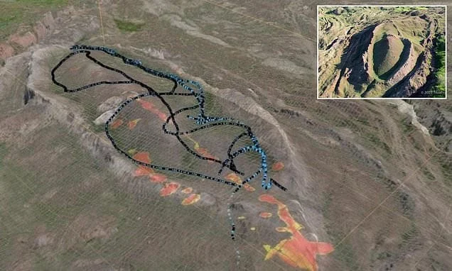
A team of international and Turkish researchers working in the rugged terrain of eastern Turkey has released new scanning data suggesting that a prominent, boat-shaped geological formation long debated by scientists and theologians could indeed be the remains of the biblical Noah’s Ark. The formation, situated near Mount Ararat in the Doğubayazıt district of Ağrı province, has drawn intense scientific scrutiny and public fascination for decades. Recent geological surveys, advanced ground-penetrating radar scans, and core sampling campaigns have injected fresh momentum into the ongoing quest to verify one of history’s most enduring maritime mysteries.
The ongoing scientific investigation centers on the Durupinar site, a boat-shaped geological structure measuring approximately 157 meters in length. According to recent statements made by Andrew Jones, a lead researcher representing the California-based exploration organization Noah’s Ark Scans, the latest scanning data reveals structural anomalies that defy standard natural explanations. Speaking on national television, Jones asserted his belief that the site contains the weathered, subsurface remains of the legendary vessel. The research team emphasizes that their current methodology relies heavily on empirical data collection, modern geophysics, and rigorous archaeological standards rather than purely speculative theories, aiming to convince skeptics through transparent scientific disclosure.
Chronology and Research Timeline of the Durupinar Formation
The modern history of the Durupinar site dates back to the mid-twentieth century, intertwining aerial reconnaissance, military cartography, and grassroots archaeological exploration. The formation first came to international prominence in 1959 when a Turkish air force pilot, Captain İlhan Durupınar, spotted the peculiar boat-shaped outline while conducting aerial mapping photography for NATO. The striking symmetry and precise dimensions of the formation immediately captured the attention of researchers, most notably American explorer Ron Wyatt, who conducted independent investigations at the site during the 1970s and 1980s.
Despite early enthusiasm, mainstream archaeological and geological communities remained largely skeptical for decades, dismissing the site as a natural geological anomaly—specifically, an unusual mud volcano or an eroded syncline ridge formed by tectonic pressures and soil creep. Geologists pointed out that natural erosion patterns can occasionally produce symmetrical, streamlined landforms that mimic human-made structures when viewed from above.
The dynamic shifted significantly in the 2000s and 2010s as non-destructive subsurface imaging technologies advanced. Researchers began utilizing electrical resistivity tomography (ERT), ground-penetrating radar (GPR), and high-resolution seismic surveys to look beneath the topsoil without disturbing the underlying strata. A collaborative research framework was gradually established between independent Western exploration groups and Turkish academic institutions, leading to formal authorization from the Turkish government to conduct comprehensive geological testing.
In September of recent years, a joint research initiative formally commenced after securing official permits. The multidisciplinary team brought together geologists, geophysicists, and archaeologists, notably led by Cenker Atila, an expert from Turkey’s Sivas Cumhuriyet University, alongside international partners from Noah’s Ark Scans. The fieldwork involved drilling boreholes and extracting soil and rock samples from depths reaching up to 18 meters along the southern perimeter of the formation. These samples were subsequently sent to certified laboratories for mineralogical, chemical, and carbon-dating analyses to determine the chronological age of the surrounding sediments and to identify any foreign organic or inorganic compounds that might indicate ancient construction materials.
Technical Analysis and Geological Data
At the heart of the ongoing debate is the precise physical morphology and material composition of the Durupinar site. Measuring roughly 157 meters long, the formation closely aligns with the biblical description of Noah’s Ark found in the Book of Genesis, which specifies the vessel’s dimensions in ancient cubits that roughly translate to modern measurements of approximately 150 meters. However, scientific validation requires moving beyond dimensional coincidences to examine subsurface signatures.
Data retrieved from recent ground-penetrating radar scans revealed parallel lines and angular subsurface structures embedded within the mud and clay matrix. Researchers argue that these reflective anomalies do not conform to the chaotic, random stratification typical of natural sedimentary deposits. Instead, they suggest the presence of grid-like internal bulkheads or compartmentalized spaces, which would be consistent with the internal framing of a massive wooden watercraft.
Furthermore, soil analysis from the core samples has identified anomalous concentrations of specific elements and clay minerals. Some preliminary laboratory tests have hinted at the presence of limonite-coated iron compounds, which researchers hypothesize could be the chemical remnants of rusted metal fasteners, brackets, or bracing elements used to reinforce ancient timber frames. Additionally, geologists have analyzed the surrounding terrain, noting that the formation rests on a layer of older marine and alluvial deposits, which supports the hypothesis that the region experienced catastrophic, high-energy flooding events in prehistoric epochs.
Despite these intriguing data points, the scientific community remains deeply divided. Critics within mainstream geology and archaeology emphasize that complex geological processes—such as differential weathering, sliding tectonic blocks, and mass-wasting events—can create layered subsurface geometries that mimic man-made walls or internal structures. Independent geologists have repeatedly called for peer-reviewed publication of the complete radar datasets and exhaustive independent verification of the laboratory sample results before any definitive claims regarding the artifact’s artificial nature can be accepted by the broader academic establishment.
Official Responses and Institutional Involvement
The investigation near Mount Ararat operates under strict regulatory oversight by the Turkish government, reflecting the high cultural, historical, and geopolitical sensitivity of the region. The Ministry of Culture and Tourism, alongside local administrative bodies in Ağrı province, has carefully balanced the promotion of cultural tourism with the necessity of preserving archaeological integrity.
Turkish universities, particularly Sivas Cumhuriyet University and Ağrı İbrahim Çeçen University, have played an instrumental role in providing academic legitimacy and technical oversight to the field expeditions. By integrating Turkish researchers into leadership roles, the projects ensure adherence to national antiquities laws and foster international scientific cooperation. Local authorities have also invested in infrastructure improvements around the Durupinar site, establishing visitor centers, observation platforms, and informational signage to accommodate the steady influx of tourists, pilgrims, and curious travelers from around the globe.
International organizations, while maintaining cautious academic detachment, have closely monitored the developments. While major archaeological bodies such as the Archaeological Institute of America or the Biblical Archaeology Society generally approach such claims with rigorous skepticism, the deployment of advanced georadar technology has earned the current generation of researchers a higher degree of academic attention than previous amateur expeditions received in the late twentieth century. Representatives from Noah’s Ark Scans have consistently stated their intention to publish their findings in peer-reviewed scientific journals, a crucial step toward bridging the gap between independent exploration teams and institutional academia.
Broader Impact, Implications, and Future Outlook
The ongoing exploration of the Durupinar formation carries profound implications across multiple disciplines, including archaeology, historical geology, ancient anthropology, and global cultural heritage. If future excavations and comprehensive laboratory analyses can conclusively demonstrate that the structure is indeed the remains of an ancient, human-engineered vessel dating back several millennia, it would necessitate a profound reassessment of early maritime engineering capabilities and historical chronologies.
From a cultural and theological perspective, the site attracts millions of individuals from diverse religious traditions who view the potential verification of the ark as a tangible connection to sacred narratives found within Abrahamic texts, including the Bible and the Quran. The cultural resonance of Mount Ararat as a universal symbol of survival, renewal, and shared human heritage elevates local economic development in eastern Turkey, transforming remote rural districts into global hubs for educational and religious tourism.
Conversely, the scientific implications demand an unwavering commitment to empirical rigor. Researchers involved in the project face the dual challenge of advancing their exploratory goals while maintaining absolute transparency in data sharing. The scientific method requires that all radar profiles, core sample analyses, and dating results be subjected to independent replication and critical peer review. Without such validation, the site risks remaining mired in perpetual controversy, divided between fervent believers seeking divine confirmation and skeptical scientists demanding undeniable physical proof.
As the research consortium prepares for subsequent phases of fieldwork, the focus will likely shift toward non-destructive micro-analytical techniques and deeper targeted drilling to retrieve intact structural material. Whether the Durupinar formation ultimately yields the definitive smoking gun of ancient shipbuilding or is definitively classified as a remarkably deceptive geological masterpiece, the ongoing scientific endeavor near Mount Ararat continues to captivate the human imagination, bridging the ancient past with the cutting edge of modern geophysical exploration.
