

The Indonesian government has underscored the critical importance of spatial planning as a foundational tool to guarantee clear land-use designations and ensure that national territory is managed in an organized, sustainable manner. During a high-level coordination meeting held at the Ministry of Coordinating Bureau for Food Affairs in Jakarta, top government officials convened to finalize the mapping and protection policies governing national agricultural zones. The primary objective is to harmonize various competing demands for land—ranging from food security and residential housing to industrial development and energy infrastructure—under a singular, authoritative national reference map.
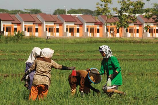
This strategic push comes at a time when rapid economic growth, industrialization, and demographic expansion are exerting unprecedented pressure on Indonesia’s limited land resources. By leveraging rigorous spatial planning, the administration aims to mitigate land-use conflicts, protect vital agricultural productivity, and provide long-term regulatory certainty for both public infrastructure projects and private sector investments.
Background and Context of National Land-Use Policies
Indonesia’s ongoing struggle with agrarian management has historically been marked by sectoral egoism, uncoordinated conversions, and overlapping permits. Fertile agricultural land is frequently converted into commercial, industrial, or residential properties, threatening long-term food security. To address these systemic vulnerabilities, the central government has integrated robust land protection frameworks into its overarching strategic planning documents.

A cornerstone of this legislative effort is Presidential Regulation Number 12 of 2025 concerning the National Medium-Term Development Plan (RPJMN) spanning 2025 to 2029. Within this roadmap, the government has established ambitious benchmarks to safeguard arable land, specifically targeting the protection of Sustainable Food Agriculture Land (LP2B) to reach a minimum of 87 percent of the total Raw Rice Field Land (LBS) nationwide by 2029.
This policy framework was further reinforced by Presidential Regulation Number 4 of 2026, which specifically regulates the control of agricultural land conversion. The regulation mandates the strict enforcement of Protected Rice Field (LSD) maps and mandates their seamless integration into regional spatial plans and LP2B targets. Through these legislative instruments, Jakarta seeks to establish an enforceable legal barrier against arbitrary land-clearing practices.

Chronology and High-Level Deliberations
The recent push culminated on Monday, September 7, 2026, during the Finalization Meeting on the Provincial Protected Rice Field Map (LSD) and the expansion of LP2B integration. The closed-door session brought together key national decision-makers to evaluate regional progress and address implementation bottlenecks.
The meeting was chaired by Coordinating Minister for Food Affairs Zulkifli Hasan, who emphasized that spatial planning serves as the ultimate instrument to resolve competing national interests. Also in attendance were Minister of Agrarian Affairs and Spatial Planning/Head of the National Land Agency (ATR/BPN) Nusron Wahid, Minister of Housing and Settlement Areas (PKP) Maruarar Sirait, Deputy Head of Statistics Indonesia (BPS) Sonny Harry, alongside delegates from various ministries and governmental agencies.

During the session, the coordinating minister highlighted that Indonesia’s national rice field area currently hovers around 7 million hectares. Maintaining this volume requires strict adherence to unified mapping standards.
"The government continues to strengthen food land protection through spatial planning policies and the control of agricultural land conversion. One of our primary legal anchors is Presidential Regulation Number 12 of 2025 concerning the National Medium-Term Development Plan for 2025–2029," stated Zulkifli Hasan in an official release following the meeting.

Balancing Food Security and Public Housing Needs
A central theme of the ministerial discussions was the delicate balancing act between preserving agricultural land and fulfilling the acute demand for public housing and urban expansion. Minister of Housing and Settlement Areas Maruarar Sirait noted that while food security remains an absolute national priority, spatial allocations must simultaneously account for housing and developmental needs to avoid future bottlenecks.
"We know food is number one, the most important thing. We also know housing is a critical priority for our citizens. Our position is clear: we must ensure that agricultural programs succeed while housing programs also succeed," Maruarar explained.

The Minister of PKP advocated for comprehensive regional planning where municipal and provincial zones are demarcated clearly from the outset. By designating specific tracts for agriculture, housing, green energy, and industrial activities within a unified master plan, sectors can develop concurrently without adversarial land-use clashes. Furthermore, Maruarar emphasized that clear spatial zoning provides much-needed regulatory clarity for property developers and business entities, enabling them to invest with confidence in legally compliant zones.
Regional Compliance and Data Evaluation
Progress reports presented during the coordination meeting indicated notable headway in regional compliance throughout 2026, though challenges remain at the local level. Minister of ATR/BPN Nusron Wahid outlined the evolutionary trajectory of LP2B adoption over the course of the year.

In January 2026, provincial Spatial and Regional Plans (RTRW) incorporating LP2B targets stood at a modest 68 percent, while regency and municipal RTRW implementations lagged even further behind at 41.72 percent. However, aggressive administrative follow-ups yielded significant improvements by September 2026. Leadership across all provincial administrations successfully signed temporary decrees (SK) concerning LP2B establishment, bringing the national aggregate coverage to an impressive 87.52 percent of total LBS.
Despite this aggregate success, the Ministry identified seven provinces that currently fall below the required compliance targets. The central government has issued a strict timeline for these lagging regions to finalize their zoning frameworks and meet statutory benchmarks.

Statistics Indonesia (BPS) specifically flagged the provinces of Bali and Banten as regions requiring targeted intervention. Both territories possess high agricultural potential but face severe systemic pressures due to rapid commercialization—specifically the proliferation of industrial zones in Banten and expansive tourism-driven real estate development in Bali.
Implications and Future Outlook
The concerted inter-ministerial focus on spatial planning and land protection carries profound economic, social, and environmental implications for Indonesia. By enforcing a single-map policy, the government reduces administrative ambiguity, curtails illegal land conversions, and builds a predictable investment climate.

For the agricultural sector, the enforcement of 87 percent LP2B coverage safeguards national food sovereignty against the headwinds of rapid urbanization. Simultaneously, by structuring urban and rural development through holistic regional blueprints, sectors such as real estate and infrastructure can expand predictably without compromising ecological stability or food production lines.
As the government moves to hold non-compliant regional authorities accountable and integrates localized master plans into national databases, Indonesia steps closer to resolving the eternal friction between conservation and modernization—ensuring that land allocation serves both present human needs and future generational sustainability.
