
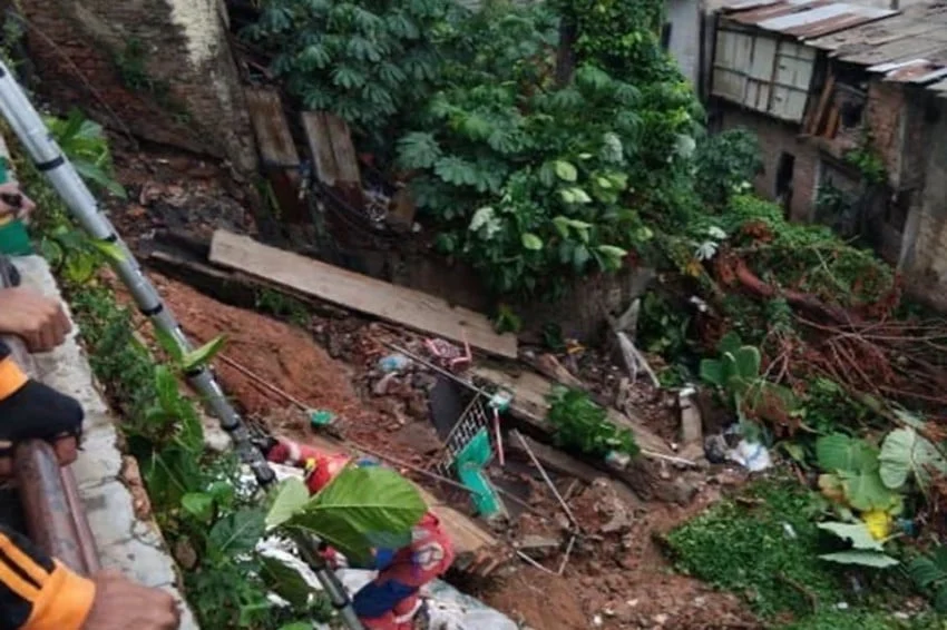
A destructive landslide struck a densely populated residential neighborhood along Jalan Kemang Selatan X, Bangka Sub-district, Mampang Prapatan District, South Jakarta, following a combination of torrential downpours and progressive soil destabilization. The natural disaster, which unfolded during the early
afternoon hours, inflicted significant structural damage on local properties, destroyed perimeter infrastructure, and forced multiple households to flee their homes in search of safe temporary shelter. While prompt emergency responses prevented any casualties or severe injuries, the incident has reignited urgent concerns regarding urban environmental vulnerability, soil stability in low-lying riparian zones, and the intensifying impacts of extreme weather events across the Indonesian capital.
According to official incident reports released by the Jakarta Regional Disaster Management Agency (BPBD DKI Jakarta), the geological failure occurred precisely at 2:10 PM local time. The disaster zone encompasses a residential pocket situated near local water bodies, where steep embankments and saturated soil profiles are exceptionally susceptible to gravitational collapse during periods of sustained, heavy precipitation. The primary catalyst for the disaster was identified as a relentless downpour that battered South Jakarta throughout the morning and early afternoon, severely compromising the structural integrity of earthworks and retaining walls within the affected neighborhood.
Main Facts and Immediate Aftermath of the Kemang Landslide
The landslide severely impacted a localized sector of Jalan Kemang Selatan X, causing a sudden structural collapse of earth embankments and heavy masonry walls. Preliminary impact assessments conducted by disaster response teams indicate that the disaster directly damaged five residential structures situated immediately adjacent to the sliding slope. Furthermore, massive retaining walls and structural earth boundaries belonging to local commercial or residential parcels—referred to locally as padel facilities—suffered catastrophic structural failure, cascading downward and compounding the destruction of the homes below.
Despite the terrifying nature of the collapse, emergency services confirmed that swift evacuation efforts and the fortunate positioning of residents prevented any loss of life or severe physical injuries. However, the psychological toll and physical disruption have been immediate. BPBD DKI Jakarta confirmed that a total of eight heads of households (KK), encompassing dozens of individual residents, were forced to evacuate their compromised properties immediately following the event. These families have been relocated to secure temporary safe zones while municipal engineers and structural geologists conduct comprehensive safety assessments to determine whether the remaining residential structures can be reoccupied or if they face imminent secondary collapse risks.
Chronology of the Disaster
A detailed reconstruction of the event reveals a rapid sequence of environmental failure and emergency mobilization. The morning of the incident began with steady, moderate rainfall that rapidly intensified into a torrential downpour by noon, inundating South Jakarta’s drainage networks and saturating the topsoil layers throughout the Mampang Prapatan area.
At approximately 2:00 PM, residents in the Jalan Kemang Selatan X neighborhood reported hearing an unusual, deep-seated rumbling sound, accompanied by distinct ground vibrations beneath their foundations. Minutes later, at precisely 2:10 PM, the saturated embankment gave way entirely. The sudden shear failure caused a massive volume of mud, rock, and fractured concrete to break through residential boundaries, crushing exterior walls, filling backyards, and breaching the living spaces of several homes.
Local residents immediately raised the alarm, contacting neighborhood wardens (RT/RW), local police, and the regional disaster hotline. Within minutes, rapid response units from BPBD DKI Jakarta, local fire and rescue services (Gulkarmat), the sub-district administration, and public safety personnel were dispatched to the scene. First responders immediately secured the perimeter to prevent curious onlookers from entering the unstable zone, cut off local electrical supplies to mitigate fire hazards from downed power lines, and assisted vulnerable residents—including children and the elderly—in evacuating the danger zone before secondary soil shifts could occur.
Background Context: Urban Hydrology and Geological Vulnerability in South Jakarta
To fully understand the landslide in Kemang Selatan X, it is essential to examine the broader geographical and hydrological context of South Jakarta. The region is characterized by numerous winding rivers, ancient floodplains, and low-lying alluvial valleys that have experienced rapid, intensive urban development over the past four decades. Historically, these zones functioned as natural water retention areas and green buffers, absorbing excess runoff and maintaining subsurface hydrological equilibrium.
However, rapid urbanization, commercial expansion, and residential densification have drastically altered the natural landscape. Natural vegetation and permeable topsoils have been extensively replaced by concrete, asphalt, and heavy structural foundations. In upscale and commercialized neighborhoods like Kemang, the proliferation of real estate developments often involves terracing, retaining wall construction, and the modification of natural slopes along local waterways, such as the Krukut River basin.
When extraordinary meteorological events occur—such as extreme precipitation episodes driven by regional monsoons or climate-induced weather anomalies—urban drainage systems are frequently overwhelmed. Rainwater infiltrates modified soil structures far beyond their natural saturation thresholds, increasing pore water pressure within the earth. As internal water pressure rises, the cohesive strength of the soil declines precipitously, transforming solid ground into a liquefied mass capable of triggering devastating downward movements under the force of gravity.
Official Responses and Inter-Agency Coordination
In the wake of the disaster, municipal authorities have mobilized a multi-agency response aimed at stabilization, victim support, and long-term mitigation planning. Marulitua Sijabat, Head of the Executive Board of BPBD DKI Jakarta, provided continuous updates to the public regarding the emergency operations. He emphasized that the primary focus of the provincial government remains the safety and welfare of the displaced families, alongside the prevention of further infrastructural damage in the surrounding blocks.
"The objects directly impacted by this geological failure include substantial retaining walls, property land parcels, and five residential dwellings situated along the slope," Marulitua stated during an official press briefing. "The primary driving force behind this event was the combination of prolonged, heavy rainfall and localized soil displacement. Upon hearing initial tremors and rumbling sounds, residents acted with commendable alertness, allowing for a rapid and orderly evacuation before structural integrity was entirely lost."
Marulitua also addressed the status of material losses and victim assistance, noting that while no fatalities or injuries were recorded, the calculation of total material damages remains ongoing. "Our field teams, in collaboration with the Public Works Agency, the Water Resources Agency, and local district authorities, are currently conducting a comprehensive inventory of the structural losses. We are also ensuring that temporary shelter, clean water, and basic humanitarian provisions are adequately supplied to all evacuated citizens," he added.
In tandem with BPBD, the Jakarta Department of Water Resources (SDA) deployed heavy equipment and engineering assessment teams to inspect the drainage channels and riverbanks adjacent to Jalan Kemang Selatan X. Engineers are evaluating whether erosion along the nearby river channel contributed to the undermining of the slope’s base. Temporary countermeasures, including the installation of heavy-duty tarpaulins to prevent further rainwater infiltration into the exposed earth scar and the erection of emergency scaffolding, are currently being deployed to stabilize the slope against upcoming weather forecasts.
Broader Impacts, Economic Implications, and Mitigation Challenges
The Kemang Selatan X landslide is not an isolated incident; it reflects a recurring set of environmental vulnerabilities that plague densely populated urban centers across Indonesia during the rainy season. Similar slope failures and ground subsidence events have been documented across surrounding regencies, including recent incidents in Bogor and various hilly terrain sectors of Greater Jakarta. These events collectively underscore the mounting economic and social costs of climate change adaptation failures in rapidly growing metropolitan environments.
From an economic perspective, incidents of this nature impose substantial financial burdens on both private property owners and municipal governments. Homeowners face devastating devaluation of their real estate assets, costly structural engineering repairs, and potential protracted legal disputes regarding property boundaries and liability for retaining wall maintenance. Meanwhile, local governments are forced to reallocate significant budgetary resources toward emergency response, disaster relief provisioning, infrastructure rehabilitation, and long-term civil engineering fortifications.
Urban planning experts emphasize that mitigating future disasters of this magnitude requires a paradigm shift in municipal governance and zoning enforcement. Traditional reactive disaster management—responding only after collapses occur—must be replaced by proactive, data-driven spatial planning and stringent environmental oversight. Key policy recommendations frequently advanced by academic and institutional geologists include:
- Comprehensive Geological Mapping: Conducting high-resolution geotechnical surveys across all urban residential zones built on sloped terrain or riparian corridors to identify high-risk subsidence zones before failures occur.
- Strict Zoning Enforcement: Enforcing strict setbacks and building prohibitions along riverbanks and steep artificial embankments to prevent high-density residential loading on unstable soil profiles.
- Modernized Drainage Infrastructure: Upgrading urban drainage networks to handle extreme precipitation volumes safely, preventing the accumulation of excessive pore water pressure in vulnerable hillsides.
- Mandatory Retaining Wall Inspections: Instituting regular municipal safety audits for private and commercial retaining walls, particularly in commercialized districts like Kemang where structural modifications are widespread.
As climate models project an increase in the frequency and intensity of extreme weather events across Southeast Asia, the resilience of Jakarta’s urban infrastructure will continue to be tested. The prompt and coordinated response to the Jalan Kemang Selatan X landslide averted immediate tragedy, but the event serves as a stark reminder of the urgent need for comprehensive environmental stewardship and rigorous engineering standards to safeguard urban communities in the years ahead.